|
CIPS:
CLOUD IMAGING AND PARTICLE SIZE EXPERIMENT
Instrument Overview
The Cloud Imaging and Particle Size (CIPS)
experiment is a wide angle (120° along track by 80°
across track) imager consisting of four identical cameras
arranged in a cross pattern. CIPS provides images of PMCs
with a spatial resolution of 1 x 2 km in the nadir and about
5 km at the edges of the forward and aft cameras.
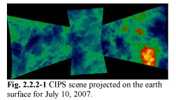
The four CIPS camera images are merged
and binned to form a single display we call a scene with an
averaged spatial resolution of 5 x 5 km. A scene is depicted
in Figure 2.2.2-1 (below). The scene spatial coverage is 2000 km along
the satellite track and 1000 km across track. The red and
yellow areas depict strong PMCs in the field of view. As the
satellite moves in orbit, any given cloud is viewed seven
times at a large range of scattering angles.
The orbit-to-orbit changes of the PMC
features are revealing new information regarding their horizontal
motions, and ice particle lifetimes. For the first time, CIPS
data now make quantitative comparisons possible with global
models, because of the availability of near-simultaneous data
for temperature, water vapor, meteoric dust, and other gases
that are the key forcing parameters for mesospheric ice formation.
- CU/LASP
designs and fabricates the nadir imager instrument, CIPS,
and aligns and calibrates the channels thereof.
- Panoramic nadir imaging, 120 degrees by 80
degrees field of view (1800 x 800 km)
- Mie scattering from Polar
Mesospheric Clouds near 82 km altitude
- Derive PMC morphology
- Measure cloud particle size
- Rayleigh scattering from the background near
50 km altitude to measure gravity wave activity
- Multiple exposures of individual cloud elements
measure scattering phase function and detect spatial scales
~2 km
- Ultraviolet bandpass (265 plus or minus 5
nm) maximizes cloud contrast
Benefits of the 4-camera design:
- Reduces overall complexity of CIPS
- Reduces CIPS data volume by 33%
- Reduces AIM data volume by a similar amount
(CIPS is the predominant bit producer)
- Lowers CIPS parts costs, subassembly test
costs and mass
|


