A recent study examined variations in interstellar dust (ISD) and the interplanetary dust (IPD) flux at Earth, using observations from three different satellite techniques [Hervig et al., 2022]. First are size-resolved in situ meteoroid detections by the Ulysses spacecraft, and second are in situ indirect dust observations from the Wind spacecraft. Third are measurements of meteoric smoke in the mesosphere by SOFIE. Wind and Ulysses observations are sorted into the interstellar and interplanetary components. ... more at mission status update->
The Aeronomy
of Ice
in the Mesosphere (AIM) satellite mission is exploring Polar Mesospheric Clouds
(PMCs), also called noctilucent clouds, to find out why they
form and why they are changing.
The AIM mission was launced April 25, 2007 and has been extended by NASA through the end of FY20. During this time the
instruments monitor noctilucent clouds to better understand
their variability and possible connection to climate change.
Individual instrument data collection status, as well as spacecraft
and instrument health, will be monitored throughout the life
of the mission and reported periodically on this website.
The primary goal of the AIM mission is to help scientists understand whether the clouds' ephemeral nature, and their variation over time, is related to Earth's changing climate - and to investigate why they form in the first place. By measuring the thermal, chemical and other properties of the environment in which the mysterious clouds form, the AIM mission will provide researchers with a foundation for the study of long-term variations in the mesosphere and its relationship to global climate change. In addition to measuring environmental conditions, the AIM mission will collect data on cloud abundance, how the clouds are distributed, and the size of particles within them.
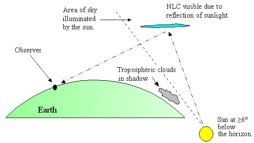
Glowing silver-blue clouds that sometimes light up summer night skies at high latitudes, after sunset and before sunrise, are called noctilucent clouds. Also known as night shining clouds, they form in the highest reaches of the atmosphere – the mesosphere – as much as 50 miles (80 km) above the Earth’s surface. They’re seen during summer in polar regions. They’re typically seen between about 45° and 60° latitude, from May through August in the Northern Hemisphere or November through February in the Southern Hemisphere.
Noctilucent clouds are thought to be made of ice crystals that form on fine dust particles from meteors. They can only form when temperatures are incredibly low and when there’s water available to form ice crystals.
Why do these clouds – which require such cold temperatures – form in the summer?
Observing tips: Look west 30 to 60 minutes after sunset when the Sun has dipped 6o to 16o below the horizon. If you see luminous blue-white tendrils spreading across the sky, you've probably spotted a noctilucent cloud. Although noctilucent clouds appear most often at arctic latitudes, they have been sighted in recent years as far south as Colorado, Utah and Virginia. NLCs are seasonal, appearing most often in late spring and summer. In the northern hemisphere, the best time to look would be between mid-May and the end of August.
ALERT: AIM reentered the Earth's atmosphere on the morning of August 19, 2024.
AIM NASA SCIENCE RELEASES
Tiny Meteors Leave Smoke in the Atmosphere. NASA's Studying It.
Date: December 13, 2021
NOCTILUCENT CLOUD SEASON HAS BEGUN: NASA's AIM spacecraft has detected a noctilucent cloud (NLC) inside the Arctic Circle--the first of the 2020 summer season. It is the blue puff in this satellite image of the North Pole. The detection on May 17th marks one of the earliest starts in the 14 year history of the spacecraft. "In previous years, we have seen the first NLCs appear between May 15th and May 27th," says Cora Randall, a member of the AIM science team at the University of Colorado. "Only once, in 2013 (May 15th), has the northern season started earlier than this."
2020 Northern Hemisphere NLC Forecast
Date: May 10, 2020 Spaceweather.com
Excerpt: Moisture and temperature are key ingredients of NLCs. The clouds flourish when the mesosphere is extra cold and wet. Harvey's plots show 2020 (red) splitting right down the middle of other recent years--not too cold and not too wet.
"So far, 2020 is shaping up to be fairly average," says Harvey. In other words, 2020 does not look a repeat of 2019. This summer's clouds might be confined to higher latitudes again.
No one will know for sure, however, until NLC season actually begins. Daily images of NLCs from NASA's AIM spacecraft are posted on Spaceweather.com [and on AIM]. "Based on the MLS data, I would guess that the first NLCs will be spotted in two weeks or so," she says. Stay tuned to see if the forecast is correct!
Noctilucent (“night-shining”) cloud over Antarctica in early January, 2018, from NASA’s AIM satellite.
The sky over Antarctica is now glowing electric blue with noctilucent, or night-shining, clouds. That’s according to recent images from NASA’s AIM spacecraft (Aeronomy of Ice in the Mesosphere), which monitors these clouds for the whole Earth. Read more ->
Space Weather News "Noctilucent Clouds from Space" Date: July 28, 2017 http://spaceweather.com
NASA's AIM spacecraft is back in business. Following a months-long interruption in normal operations, the polar-orbiting satellite is beaming back new images of noctilucent clouds at the edge of space. Data arriving now show a magnificent ring of electric-blue surrounding Earth's north pole, confirming recent sightings from the surface of our planet. Visit today's edition of Spaceweather.com to learn more about these strange clouds and the status of AIM.
NLCs are, essentially, clouds of frosted meteor smoke. They form when wisps of summertime water vapor rise toward the top of Earth's atmosphere. Water molecules stick to the microscopic debris of disintegrated meteoroids, assembling themselves into tiny crystals of ice that glow beautifully in sunlight at the edge of space.
After delayed start, magnificent noctilucent clouds are back in full effectDate: July 04, 2017
The Watchers
NASA’s AIM Observes Early Noctilucent Ice Clouds Over Antarctica Date: December 2, 2016 www.nasa.gov
Data from NASAs Aeronomy of Ice in the Mesosphere, or AIM, spacecraft shows the sky over Antarctica is glowing electric blue due to the start of noctilucent, or night-shining, cloud season in the Southern Hemisphere. This data was collected from Nov. 17-28, 2016.


